Local groups (bhuranyoga)
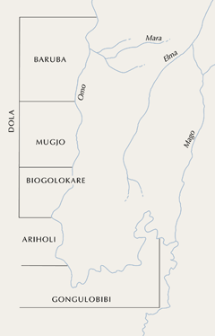
Local groups (bhuranyoga) in Mursiland. Map 5
The population is divided into five main local groups, or bhuranyoga (sing. bhuran), which are named, from north to south, Baruba, Mugjo, Biogolokare, Ariholi and Gongulobibi. Because the term bhuran refers to a group of co-resident people rather than to the physical space they occupy, it is not possible to draw clear cut spatial boundaries between bhuranyoga. What gives them their spatial definition is not that their members live within clearly bounded territorial units, but that they move back and forth, in a coordinated fashion, between the same sites for flood and rain cultivation and cattle herding. They have, in other words, territorial foci rather than territorial boundaries. (Map 5)
Some of these local divisions are relatively new, especially the two most northerly ones, Baruba and Mugjo. About 150 years ago, the ancestors of the present Mursi, coming from the west, began occupying the east bank of the Omo in a move that is seen today, in Mursi oral history, as the decisive event in creating a specifically Mursi identity. In the early years of this century, a second migration began, northwards to the River Mara which forms the present-day northern boundary of the Mursi. Both migrations represented a Mursi expansion into territory formerly inhabited by their northern neighbours, the Bodi.
Before the move to the Mara, there were three Mursi bhuranyoga, named from north to south, Dola, Ariholi and Gongulobibi, Dola covering the area currently occupied by Biogolokare. The names Biogolokare, Mugjo and Baruba, which distinguish different sub-units of Dola, came into use only gradually, after the migration to the Mara had begun and as the population of the newly occupied area grew. Before this the Biogolokare group were known as the ‘Dola of Darthum’ (a river). It was only since the 1980s that the names Mugjo and Baruba became established in everyday speech. Before that, members of these groups were generally also identified by geographical markers - the rivers around which they built their settlements and along which they cultivated. These were the Mako (a short, westward flowing tributary of the Omo, not to be confused with the much longer southward flowing tributary of the same name) in the case of Mugjo, and the Mara in the case of Baruba.
Over the years, then, new identities have been created, and older ones modified as part of a constant process of northward expansion. This expansion has been fed by a continuous south-to-north migration of individuals and families, largely through intermarriage, with the result that ties of clanship and affinity, embodied in economic cooperation and exchange, spread throughout the population, cutting across local group boundaries.
More information
- David Turton, 'The meaning of place in the world of movement: lessons from long term field research in Southern Ethiopia'. Elizabeth Colson Lecture, Refugee Studies Centre, 2004.'
- David Turton, 'A journey made them: territorial segmentation and ethnic identity among the Mursi', in Ladislav Holy (ed.) Segmentary lineage systems reconsidered, Department of Social Anthropology, Queen's University Papers in Social Anthropology, Volume 4, Queen's University, Belfast, 1979, pp. 119-43.


